Changes in fire patterns in the Chaco between 1985 and 2015
Jana Otto
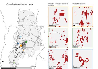
The main objective of this study is to analyse fire activity in the Gran Chaco region, and to assess how fire regimes changed over a time period of rapid land use change in the Gran Chaco since 1985. To get a more detailed view of the fire events predominantly affected land cover/use types are analysed.
By mapping the annual burned area between 1985 and 2015 temporal and spatial patterns of fires are highlighted. One objective is to identify differences between the two time periods 1985 to 2000 and
2000 to 2015 respectively. A tendency towards one of these time periods could imply that the acceleration of deforestation is somehow correlated to changes in the natural fire regime. To investigate the fire regime a classified burned area map of medium spatial resolution was created based on the Normalised Burn Ratio. The resulting map, containing information about the year in which the fire occurred was then compared to a land cover change map as well as a vegetation cover map, all based on Landsat imagery and produced by Baumann (et al. 2017 & 2018). Fire patterns were analysed on regional, national as well as on sub regional level. In general, slightly more fires were observed in the first-time span (54% of all fires) occurring primarily in forests converted to pastures. Major differences were observed among the three different countries that share the Gran Chaco region. Foremost affected was the Argentine Chaco, recording the highest number of burned areas. Fire occurred mostly in Forest to Pasture Land cover change classes but stable forest was important, too. When observing the fire regime for the individual sub regions the influence of precipitation and temperature gradient is noticeable and results in varying dominant land cover/use classes that are burned.

